Missouri Outline Perplexity & Tesla Cybercab Security Concerns
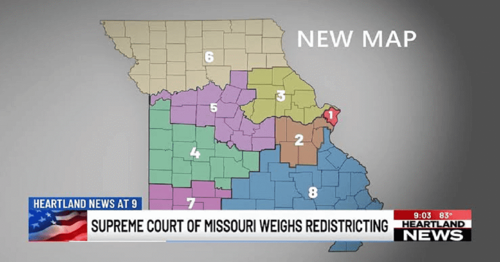
The Missouri congressional map has become one of the most closely watched redistricting stories in the United States ahead of the 2026 midterm elections. What began as a Republican-backed effort to redraw Missouri’s U.S. House districts has turned into a complicated legal and political dispute involving the Missouri Supreme Court, a federal court, the U.S. Supreme Court, state officials and voting-rights advocates.
The situation is especially important because Missouri has eight congressional districts, and changes to those boundaries can influence which party is more likely to win individual seats. The new map was designed to improve Republican prospects, including by significantly changing the Kansas City-area 5th Congressional District held by Democrat Emanuel Cleaver.
As of September 9, 2026, however, there is substantial uncertainty about which boundaries will ultimately govern the November election. The Missouri Supreme Court ruled that the new map could not be used unless voters approve it through a referendum. Shortly afterward, a federal judge issued an order requiring Missouri to use the new map, creating a conflict between state and federal court orders. The U.S. Supreme Court also declined Missouri’s emergency request to reinstate the new map.
This guide explains the Missouri congressional map, why it was redrawn, what changed, how the courts became involved and what the dispute could mean for voters and the 2026 House elections.
What Is the Missouri Congressional Map?
The Missouri congressional map is the geographic boundary system that divides the state into its U.S. House of Representatives districts.
Missouri currently has eight congressional districts. Each district elects one representative to the U.S. House. State lawmakers are responsible for establishing the boundaries, subject to constitutional and federal legal requirements. Missouri law continues to provide for eight congressional districts.
Congressional maps are normally redrawn following the decennial census because population changes can affect the size and boundaries of districts. The map created following the 2020 Census was used for recent elections.
Missouri lawmakers later approved another map in 2025. Governor Mike Kehoe signed that legislation on September 28, 2025. The state Redistricting Office subsequently published statewide and district-specific congressional maps.
The 2025 map was unusual because it represented a mid-decade redistricting effort rather than the traditional once-a-decade redrawing process.
Why Was the Missouri Congressional Map Redrawn?
The major reason behind the new Missouri congressional map was political strategy.
Republican lawmakers supported a new map that could give their party an opportunity to strengthen its position in Missouri’s congressional delegation. The effort was also connected to a larger national redistricting campaign supported by former President Donald Trump.
One of the biggest changes involved the Kansas City area. The new boundaries substantially altered the 5th Congressional District, which has traditionally been a Democratic stronghold and is represented by Emanuel Cleaver.
Under the proposed boundaries, Cleaver’s district was effectively dismantled and its Democratic voting base was redistributed into other districts. That change could have made it significantly more difficult for Democrats to retain the seat.
Republicans argued that the new boundaries were legally permissible and necessary to protect their congressional majority. Critics, however, viewed the plan as an example of partisan gerrymandering designed to produce a more favorable electoral outcome.
The dispute eventually moved beyond ordinary political disagreement and into the courts.
How the New Missouri Congressional Map Changed the Political Landscape
The most important political consequence of the new Missouri congressional map was its potential effect on the balance between Republicans and Democrats in the state’s congressional delegation.
Before the new boundaries were proposed, Missouri’s congressional delegation had a strong Republican advantage, but Democrats maintained an important foothold through the Kansas City-based 5th District.
The new map targeted that Democratic stronghold.
The redistricting plan was expected to create a map that could result in Republicans winning seven of Missouri’s eight House seats while leaving Democrats with only one. That possibility made Missouri particularly important in the national battle for control of the House.
The national stakes are significant because Republicans currently hold only a narrow majority in the U.S. House. According to Reuters, the GOP’s House advantage is 219-214, making individual districts potentially important to control of Congress.
That is why the Missouri congressional map has attracted national attention rather than remaining simply a state-level redistricting dispute.
Missouri Congressional Map and the Referendum
Opponents of the new map did not rely solely on lawsuits. They also used Missouri’s referendum process.
The group People Not Politicians organized opposition to the new congressional boundaries and submitted more than 300,000 signatures seeking a statewide vote on the legislation.
Missouri Secretary of State Denny Hoskins initially rejected the referendum effort. Opponents challenged that decision in court.
The Missouri Supreme Court eventually ruled that the referendum petition was legally sufficient and timely. The court concluded that the new congressional map could not take effect unless Missouri voters approved it.
This decision created a major problem for election officials because Missouri had already conducted its August 2026 primary elections using the new district boundaries.
The result was an unusual situation in which candidates and voters participated in a primary under one map while the legal status of that map was being challenged before the general election.
What Did the Missouri Supreme Court Decide?
On September 3, 2026, the Missouri Supreme Court unanimously blocked the new congressional boundaries from being used in the November general election unless voters first approve them.
The court’s decision meant that the congressional map adopted after the 2020 Census would remain in effect for the November election unless the legal situation changed.
The ruling was significant because it came from Missouri’s highest court and was unanimous.
The court’s decision did not simply address whether the map was politically fair. Instead, the central issue concerned the state’s referendum process and whether citizens had properly exercised their right to challenge the legislation.
The court concluded that the referendum petition was valid and that the new map had not become effective in the manner required by Missouri law.
That ruling immediately changed the status of the Missouri congressional map heading into the general election.
Why Did Missouri Appeal to the U.S. Supreme Court?
Missouri Republican officials argued that changing congressional boundaries after the primary election would create serious election problems.
Candidates had already run in the August primary using the new districts. Voters had also participated in those contests based on the new boundaries.
Missouri Attorney General Catherine Hanaway argued that the state Supreme Court decision created a constitutional crisis and sought emergency relief from the U.S. Supreme Court.
The state wanted the newly drawn map restored for the November election.
Supporters of the new map argued that returning to the older boundaries after the primary could confuse voters and candidates. They also raised concerns about election administration, ballot preparation and the fairness of changing district boundaries after primary contests had already taken place.
The U.S. Supreme Court, however, did not grant Missouri’s emergency request.
On September 8, 2026, Justice Brett Kavanaugh denied Missouri’s emergency application seeking to reinstate the Republican-drawn map. The denial was issued without a detailed explanation.
Why Is There Still Confusion Over the Missouri Congressional Map?
The legal situation became even more complicated because a federal judge issued a separate order concerning the congressional boundaries.
U.S. District Judge Stephen Clark issued a temporary order requiring Missouri to use the new map. This conflicted with the Missouri Supreme Court’s ruling that the new map could not be used without voter approval.
As a result, Missouri has faced competing judicial orders.
The state Supreme Court says the new map cannot be used unless approved through the referendum process, while the federal court has ordered the state to use the new boundaries.
That conflict has created uncertainty for election officials, candidates and voters.
The Associated Press described the situation as an unusual conflict occurring only weeks before Election Day.
The dispute is therefore not simply about where district lines should be drawn. It is also about which court order controls the election process and whether Missouri should conduct the general election using the same boundaries that were used during the primary.
What Does the Census Bureau Say About the Missouri Congressional Map?
The U.S. Census Bureau has also acknowledged the unusual circumstances surrounding Missouri.
The Census Bureau collected congressional district boundaries for the 120th Congress, including Missouri’s newly drawn 2026 boundaries. However, the agency later added a warning explaining that the Missouri Supreme Court’s September 3 decision could mean those boundaries will not actually be used for the November 2026 election.
This is an important distinction.
A map can exist in government geographic databases while still being subject to legal challenges that determine whether it will actually govern an election.
The Census Bureau’s current information therefore should not automatically be interpreted as confirmation that the new Missouri boundaries are permanently settled.
Instead, the agency has specifically warned that its 2026 Missouri congressional products may not reflect the districts ultimately used in November.
Missouri Congressional Districts
Missouri has eight congressional districts.
The districts cover different parts of the state, from the Kansas City metropolitan area in the west to St. Louis and surrounding communities in the east, as well as central, northern and southern Missouri.
The exact communities included in each district depend on the applicable map.
This is particularly important in 2026 because the state has two competing versions of the congressional boundaries: the older map based on the 2020 Census and the newer map passed by the Republican-controlled Legislature in 2025.
The Missouri Redistricting Office provides official congressional district maps and geographic information for the state’s districts.
Voters checking their district should therefore pay attention to the latest information from Missouri election authorities rather than relying on an old online map.
Why the Kansas City Area Matters
Kansas City has become the central focus of the Missouri congressional map controversy.
The existing 5th Congressional District has historically provided Democrats with a reliable path to representation in Congress. Emanuel Cleaver has represented the district for many years.
The new map significantly changed the boundaries around Kansas City and redistributed portions of the district.
That change was politically important because moving neighborhoods and communities into different districts can change the overall voting composition of a district.
Supporters of the new map saw the Kansas City changes as a way to create a stronger Republican opportunity. Opponents argued that the changes were specifically designed to weaken Democratic representation.
The controversy surrounding the 5th District became one of the clearest examples of how congressional redistricting can directly affect individual candidates and voters.
What Does the Missouri Congressional Map Mean for the 2026 Election?
The biggest question is which map will actually be used for the November 2026 general election.
The Missouri Supreme Court has said the previous map remains in effect unless voters approve the new boundaries.
However, the federal court’s temporary order has created a competing requirement to use the newer map.
The U.S. Supreme Court’s decision not to reinstate the map through Missouri’s emergency appeal adds another layer to the dispute, but it does not necessarily end all litigation surrounding the issue.
With Election Day approaching, officials must resolve the legal conflict quickly enough to finalize ballots and communicate accurate district information to voters.
For voters, the practical lesson is simple: the district listed on an older website or political article may not necessarily be the district that applies on Election Day.
Why Congressional Redistricting Matters
Congressional district boundaries can influence political representation for years.
A district map determines which communities are grouped together and which voters share a representative.
Redistricting can affect:
- Which candidates have a realistic chance of winning
- How competitive a congressional district becomes
- Which communities are represented by the same member of Congress
- The balance of power between political parties
- The geographic priorities of congressional representatives
Because the House of Representatives has 435 voting members, even a small number of competitive districts can matter nationally.
Missouri’s eight seats are therefore part of the broader struggle for control of Congress.
How Voters Can Check Their Congressional District
Missouri voters should use official election resources when determining their congressional district.
Because of the continuing legal dispute, voters should not assume that the district used in the August primary will automatically be the same district used in November.
The Missouri Redistricting Office maintains official information about congressional boundaries, while the Census Bureau provides geographic data about congressional districts.
As court decisions continue, official state election announcements will be especially important.
Voters should also verify their registration information and polling details through Missouri’s election authorities before Election Day.
The Future of the Missouri Congressional Map
The future of the Missouri congressional map depends heavily on the continuing legal battle and the referendum process.
If voters ultimately approve the new boundaries, the redrawn districts could become the state’s operative congressional map.
If voters reject the map, the older boundaries would remain relevant unless lawmakers create another legally valid redistricting plan.
The current situation is also likely to influence future discussions about Missouri’s redistricting system.
The controversy demonstrates how complicated redistricting becomes when political strategy, constitutional procedures, citizen initiatives and election administration intersect.
For Missouri voters, the most important issue is not simply which party benefits from the map. It is knowing which boundaries legally govern their vote.
Final Thoughts
The Missouri congressional map has become a major issue in the 2026 election because the state’s new district boundaries could significantly change the political balance of Missouri’s congressional delegation.
The Republican-backed map was designed in part to improve GOP chances, particularly by restructuring the Kansas City-area 5th District. Opponents challenged the plan through Missouri’s referendum process, ultimately leading to a unanimous state Supreme Court decision blocking the new map unless voters approve it.
At the same time, a federal judge ordered Missouri to use the new boundaries, producing an extraordinary legal conflict. The U.S. Supreme Court has so far declined Missouri’s request to reinstate the new map through emergency relief.
For now, the legal status of Missouri’s congressional boundaries remains one of the most important election questions in the state.
The situation can change quickly as courts issue additional rulings and election officials respond to those decisions. Anyone planning to vote in Missouri’s 2026 congressional election should therefore check official election information close to Election Day.
Frequently Asked Questions
1. What is the Missouri congressional map?
The Missouri congressional map divides the state into eight U.S. House districts. The boundaries determine which communities and voters are represented by each member of Congress.
2. Why was Missouri’s congressional map redrawn in 2025?
Missouri lawmakers approved a new map in 2025 as part of a mid-decade redistricting effort. The plan was supported by Republican lawmakers and was expected to improve Republican prospects in several districts, particularly around Kansas City.
3. Will the new Missouri congressional map be used in the 2026 election?
Its status remains legally disputed. The Missouri Supreme Court ruled that the new map cannot be used unless voters approve it through a referendum, while a federal judge separately ordered the state to use the new boundaries. The U.S. Supreme Court has declined Missouri’s emergency request to reinstate the map.
4. How many congressional districts does Missouri have?
Missouri has eight U.S. congressional districts. State law provides for eight districts for the 120th Congress as well.
5. Why is the Kansas City district important?
The Kansas City-area 5th Congressional District has traditionally been a Democratic stronghold and is represented by Emanuel Cleaver. The new map substantially changes that district, potentially making it more favorable to Republicans and increasing the party’s chances of gaining an additional House seat.

I am a professional content writer and SEO specialist with experience in creating well-researched, accurate, and user-focused content. I write about technology, business, finance, automotive, lifestyle, and trending news. My goal is to provide readers with reliable, up-to-date, and easy-to-understand information while following Google’s content quality and editorial best practices.